I’ll never forget my first run in White Mountain National Forest. We’d just arrived in the area, and it was the first trail my fiancée mentioned to me. Best part? Neither of us had the slightest clue how to pronounce its name.
That trail was to Mount Pemigewasset.
I didn’t know it at the time, but it would kick off a chain of runs that snowballed into chasing some of the most epic trails I’ve ever done. From short and sweet ones like Mount Willard to long, all-out efforts like the Presidential Traverse, this place has it all. With endless ridgelines, runnable forest paths, and beautiful waterfalls, this place has enough variety to punish reward every kind of runner.
In this guide, I’m sharing what I’ve learned from multiple trips to the Whites — from the best time to run here, to my top trail picks, to gear and logistics — so you’ve got everything you need before lacing up.
If you’re planning your own runcation, this is the guide to help you enjoy the Whites the right way.
Table of Contents
- What Runners Need to Know About the White Mountains
- Best Time to Run in White Mountain National Forest
- Running Trails in White Mountain National Forest
- Trail Running Tips for White Mountain National Forest
- Where To Stay in the White Mountains
- What To Pack To Trail Run in White Mountain National Forest
- FAQs About Running in the Whites
What Runners Need To Know About the White Mountains
The White Mountains cover nearly 800,000 acres in northern New Hampshire (and a small slice of Maine) and are home to some of the most iconic trails in the northeastern U.S.
For trail runners, this is a playground of rugged alpine ridges, dense forest singletrack, and some of the most challenging (and rewarding) terrain in the Northeast. And it’s the heart of White Mountain National Forest, with the Appalachian Trail cutting right through it and summiting some of the region’s most famous peaks.
But here’s the thing: these trails aren’t what most people picture when they think “trail running.”
Forget smooth dirt paths — here it’s giant rocks, roots in every direction, and a layer of moisture on… well, everything. It’s some of the most technical terrain I’ve ever run on, the kind that forces you to be completely in the moment, eyes locked on every step. And I think that’s why I love it so much.
It’s a sort of magic. The combination of being so in the moment but then you hit an epic viewpoint like Mount Willard or the sweeping ridgelines of the Presidentials, and you forget about the three rocks you kicked and the fact that your quads are planning a revolt against you.

And I’ll be honest: these trails will humble even the fastest runners.
I knew they were technical before my first trip, but I didn’t realize just how much they could slow you to a hike. If you care about posting fast Strava splits, the Whites might bruise your ego a bit. But if you enjoy a good adventure, they’ll win you over instantly.
Over multiple trips, I’ve learned a few things:
- Adjust your pace — these trails will dictate it for you, but just expect to be slowed to a hike many times.
- Choose shoes with real traction — I switched from my usual Salomons to something with a grippier outsole for this terrain. It’s moist, it’s technical, and you’ll need good traction.
- Respect the conditions — wet rocks, steep drops, and limited cell service mean gear choices matter (bring an emergency device like a Garmin inReach just in case).
The variety here is one of its biggest strengths. You can cruise a runnable forest trail like Franconia Falls one day, then take on an epic like the Presidential Traverse the next. And if you can catch it in the fall, the foliage is world-class — just be ready to share the trail with plenty of other hikers and runners.
Best Time To Run in the White Mountains
You can run in the Whites year-round, but the experience changes drastically with the seasons.
But, choosing the right time for your trip can make the difference between an unforgettable run and a sufferfest you’ll be telling stories about for all the wrong reasons. Here’s what to expect based on when you visit:
| Season | Best For | Pros | Cons | Kyle’s Take |
|---|---|---|---|---|
| Fall (Late Sep–Mid Oct) | Foliage runs, cooler temps | World-class colors, crisp air | Heavy crowds, busy parking | My #1 pick — worth sharing the trail for the views |
| Summer (Jun–Aug) | Big alpine routes, long days | Snow-free trails, epic ridges | Heat, humidity, relentless bugs | Perfect for Presidential Traverse — bring bug spray |
| Spring (Late Apr–Early Jun) | Quieter trails, cool weather | Less crowded, scenic meltwater | Mud, lingering snow, unpredictable weather | Nice balance — but conditions can shift fast |
| Winter (Nov–Apr) | Solitude, snow scenery | Unique, peaceful runs | Cold, ice, high skill required | Magical if you’re winter-ready; skip if you’re not |
🍁 Fall (Late September-Mid October)
- Pros: The type of peak foliage you see on postcards. Cooler temperatures make it great to run in as compared to the hot summer.
- Cons: Crowds. The trails, trailheads, and parking lots fill up fast. You’ll need to start early if you want the trails even somewhat to yourself.
- My take: If I had to pick one season, this would be it. Don’t get me wrong, I hate crowds. But the colors alone are worth the trip, even if you have to share it with everyone and their mother.
☀️ Summer (June-August)
- Pros: Snow-free trails, long daylight hours for more epic trails, plenty of runnable routes open. Alpine ridges are incredible in clear weather.
- Cons: Heat, humidity, and some of the most relentless mosquitoes and black flies you’ll ever meet.
- My Take: Great for tackling big routes like the Presidential Traverse, but be ready for bug spray, early starts, and A LOT of extra water.
🌸 Spring (Late April-Early June)
- Pros: Cooler temps, quieter trails, and a mix of snow melt and budding greenery.
- Cons: Mud, lingering snow at higher elevations, and unpredictable weather.
- My Take: A nice balance of lower crowds and decent conditions, but you’ll need to be flexible — the mountains call the shots this time of year.
❄️ Winter (November-April)
- Pros: Absolute solitude, stunning snow-covered landscapes, and a totally different way to experience the Whites.
- Cons: Requires winter running gear, spikes/microspikes, and serious knowledge of cold-weather safety. Not beginner-friendly or even recommended.
- My Take: If you’re experienced in winter mountain travel, it’s magical. If not, absolutely avoid it at all costs. Even experienced mountaineers have died here in winter.
Running Trails in White Mountain National Forest
Franconia Falls (Beginner, very runnable)
The Franconia Falls trail was one of the first trails my fiancee, Kaitlyn, and I ran when we arrived in White Mountain National Forest (the first being Mount Pemi, the next trail on the list).
The reason I put this first is because it’s realistically great for any type of runner.

For beginners, it’s flat so you won’t burn yourself getting to the summit from the big climbs of other trails on this list. It’s also great for any speed workouts or a simple easy run. And you can adjust the distance to your level. It’s almost 8 miles to the Falls and back, but you don’t have to go the entire way.
There are great views the entire way as you run along the East Branch of the Pemigewasset River. You’ll see some smaller waterfalls along the way as well, so you could make this a 3, 5, or 8-mile run depending on how you feel.

For us, we just went on an easy run and took our time. We had time to kill until our Airbnb was ready, so we just enjoyed the views.
A bit of advice would be to go early or just prepare to not park at the trailhead. There were LOTs of hikers out when we arrived (which is expected) so just plan for it.
Trail details
- Distance: 7.7 miles
- Elevation gain: 430+ feet
- Estimated time: 1.5-2.5 hours
- Trail type: Out-and-back
Mount Willard (Beginner)
You’ll start to notice a trend with a lot of these trails.
Short, but steep. And Mount Willard is no different. It’s only 3.2 miles, but has averages close to a 20% grade to the top. While not as steep as Mount Pemi, I think the view at the top of Mount Willard is far better.

And I don’t think many people would argue with me on that one.
It’s one of the more popular trails, so plan ahead if you do go. When we arrived, the trails weren’t too crowded. But it did take some time to get pictures at the top, but that’s expected with popular spots like this.
We spent a bit of time at the top here because I was really excited for this trail/viewpoint.

Then, we ran down similar to how we did with Mount Pemi.
This trail has fewer rocks and roots than other trails, but it can still get technical at points. But, if you have the time, don’t miss this one. It’s fantastic.
Trail details
- Distance: 3.2 miles
- Elevation gain: 940+ feet
- Estimated time: 2-2.5 hours
- Trail type: Out-and-back
Artists Bluff (Beginner)
I’ll admit, I added this because I feel it’s one of those White Mountain National Forest trails you must see, no matter how touristy/popular.

And, don’t get me wrong, the view is beautiful. But the running route is relatively short, and the beginning is a pretty steep climb before you get a gradual downhill after the viewpoint.
I had a lot of fun after the viewpoint.
The trail was a bit technical at points, but I could still let go and have fun with a fast run downhill.

The other downside is that, because of the beautiful viewpoint, this trail is usually PACKED with people. So you’ll likely have to slow down or stop as you allow for others to take their time.
So I’d advise getting their early to avoid the crowds. Other than that, be sure to stop off so you see it, but head over to another trail for a better running experience.
Trail details
- Distance: 1.3 miles
- Elevation gain: 450+ feet
- Estimated time: 1-1.5 hours
- Trail type: Loop or out-and-back
Peaked Hill Pond (Beginner)
Peaked Hill Pond was actually an unexpected trail.
We hadn’t planned to do much this day, and after a few days of higher elevation, we wanted something a bit flatter.
Enter the Peaked Hill Pond trail.

The trail starts out gradually uphill alongside a small ravine, but it’s nothing compared to the other climbs we had on other trails — averaging just under a 10% grade most of the way.
But that just allowed me to enjoy the trail a bit more.
I loved the scenery along the way. You’re running through forest most of the time, but it’s perfect as it mostly outlines the trail and creates a really cool running environment. Then, after a short downhill to the pond, you get spectacular views and a super relaxing area to hang out, enjoy the view, or maybe have a snack.

Then, you follow the way you came for the trail and get to enjoy the gradual downhill now. Overall, a great trail to do and a nice mix with all the elevation of the trails prior to this one.
Trails details:
- Distance: 4 miles
- Elevation gain: 530+ feet
- Estimated time: 1-1.5 hours
- Trail type: Out-and-back
Mount Pemigewasset (Beginner-Intermediate)
Mount Pemigewassett (pem-ee-geh-wah-sit) was the first trail we hit as we cruised into the White Mountains region.
And it was a great one to start our trip off. We did it as a mix of a hike and run. The beginning is a bit steep, averaging close to a 20% grade until we reached the top.

When we finally did, we had climbed around 1,200 feet across 1.5 miles. But the view at the top made me forget about the burn in my legs for a bit.
We spent a bit of time at the top, with only a few others at the top with us, before we started our run down.

This part was a ton of fun as it can get rooty and a bit technical, so if you enjoy this then you’ll have a ton of fun. We also passed many of the people who had been at the top with us, many of them cheering us on as we went by.
So if you want some elevation gain and a fast descent, Mount Pemi is a solid choice.
Trail details
- Distance: 3.1 miles
- Elevation: 1,230+ feet
- Estimated time: 1.5-2 hours
- Trail type: Out-and-back
Mount Moosilauke (Intermediate)
Mount Moosilauke (moose-ih-law-kee) was a trail I mostly got to run by myself.
Kaitlyn wasn’t feeling as up to a run that day, but I had been wanting something I could push myself a bit on. And I settled on Mount Moosilauke. It ended up being one of my favorite White Mountain National Forest trails I’d run on the trip.

At almost 8-miles, it was long enough. And with over 2,500 feet of elevation gain, I knew I’d get in a good workout.
Best of all, it was a loop! We hadn’t run too many loops on the trip, so I was excited for a change.
And it delivered. With the classic 15%+ grades you expect, rooty and rocky trails, and a storm blowing in that I had to race against — it was A LOT of fun.
And while the views at the top weren’t the best that day due to visibility issues, I still enjoyed the brief (and windy) time at the top. One of my favorite sections was at the top as well around mile 4 (running counter-clockwise) with high bushes on both sides of you and a gradual descent.

It allowed me to pick up the pace after a tough climb and start letting my legs go.
Overall, one of my favorite trails in the White Mountain area. But not necessarily for every runner.
Trail details
- Distance: 7.7 miles
- Elevation gain: 2,500+ feet
- Estimated time: 2-3 hours
- Trail type: Loop or out-and-back
Mount Kearsarge (Intermediate)
I really enjoyed Mount Kearsarge.
Kaitlyn? Maybe not so much. She loved the trail, the view, and everything about it. But she didn’t enjoy keeping up with me on the trail as much.

But she’d definitely up to do it again (at a slower pace) next time.
It starts out at around a 10% grade until jumping to 20% around mile 1. Then it’s up another 2,000 feet for about 2.5 miles to the summit.
Unfortunately there was a bit of smoke blowing into the area at the time we were there, so this really obstructed the view at the top. But, regardless, we enjoyed ourselves at the top and climbed the fire tower before heading back down.

And this downhill is a ton of fun to let go and bomb down. You go down the same way that you came up. So it’s a pretty easy trail to follow. And there will be some moments when you have to slow up due to the terrain. But, for the most part, you can just let go and glide down the hill.
This is a great trail if you want to hike the way up then run the way down.
Trail details
- Distance: ~6 miles
- Elevation gain: 2,500+ feet
- Estimated time: 1.5-3 hours
- Trail type: Out-and-back
Plan your next runcation without overthinking it
A free, runner-tested weekend kit with:
- A simple trip-planning framework
- A packing checklist that actually works
- A quick decision guide for short travel runs
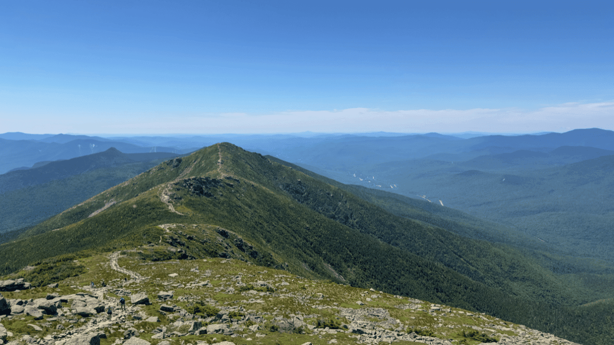
Franconia Ridge Loop (Intermediate-Advanced)
I followed up my Presidential Traverse run with the Franconia Ridge Loop a few days later.
With limited time in the area, the chance to knock out two big trails in the White Mountains was too tempting to pass up…recovery be damned! And the trail slapped me in the face right off the bat.

We did it counter-clockwise and It starts with a continual climb, getting steeper as you go up in elevation until you finally reach the peak of Little Haystack where you’ll get your first “wow” (or, in my case, “holy shit!) moment. The mountains and valleys stretch out in all directions, and you get your first good look of just how beautiful this area is. It’s where I realized why many people consider this the best trail in the Whites.
From there it winds up and down along the ridgeline as you pass over Mount Lincoln and then finally Mount Lafayette (two peaks that reach over 5,000′). Be careful not to trip along the way as you stare out at the views. I know I did a couple times.
After Mount Lafayette, it’s a steep and brutal downhill consistently to the bottom. We tried running this part, but it was more of a “rike,” (run + hike) which I don’t know if it’s been used before but I feel it’s accurate.
Overall, this is one of the best trails in the area and a must-see. Just be prepared for a long run/hike.
Trail details
- Distance: 8 miles
- Elevation gain: 3,800+ feet
- Estimated time: 4-6 hours
- Trail type: Loop
Presidential Traverse (Advanced, all-day epic)
I ran the Presidential Traverse for the first time in 2025.

And it was just as epic as I figured it’d be. Most people backpack this across 2-3 days. There are Appalachian Mountain Club (AMC) huts along the way to stop at or in case of bad weather.
But I just decided to do it in one day to go full send.
And, boy, was it an experience. 19 miles. 8500 feet of gain. And 8.5 hours of running along ridgelines. It’s definitely a full-on type 2 kind of fun. It beat me up, but I loved every minute of it.
The only reason I added it as a bonus is because, realistically, it’s difficult for most runners to actually run this trail because of the terrain.
But still VERY MUCH worth doing.
Trail details:
- Distance: 19 miles
- Elevation gain: 8,500+ feet
- Estimated time: 6-12 hours
- Trail type: Point-to-point
Trail Running Tips for White Mountain National Forest
Running in the Whites isn’t like heading out on your local park trail.
It’s rugged, steep, and technical enough to keep even the most seasoned trail runner on their toes… literally. But that’s part of the charm. Over the years (and more than a few trips), I’ve learned a handful of lessons that make running here a whole lot more enjoyable — and safer.
1. Respect the Terrain When Trail Running in White Mountain National Forest
The Whites are famous for their rocks, roots, and damp…well, everything is damp.
And even the best trail shoes will slip now and then. So picking a good pair of shoes with even better grip is essential. I’ve seen runners and hikers in road shoes or even tennis shoes and they get chewed up by the terrain.
Do yourself a favor and pick something sticky with deep lugs.

2. Plan for the Weather
Mountain weather here changes faster than you think.
I’ve started runs in short sleeves and ended with gloves and a rain shell. And it’s even more important if you’re headed above treeline.
So, check the summit forecasts (not just the nearest town) and always have a bail route if necessary.
The best options to check the summit forecasts are Mountain Forecast and the Mount Washington Observatory. Always check up until the time you start your run. Things can change quickly.
3. Navigation is Non-Negotiable
Cell service is spotty at best, and nonexistent at worst. I always download offline maps to my phone and watch.
And, just for added safety, I’ll carry the Garmin inReach Mini in case I get in a sticky situation. Even on well-marked trails, fog or fatigue can make navigation tricky.
And it’s always good to have something with you just in case.
Plan your next runcation without overthinking it
A free, runner-tested weekend kit with:
- A simple trip-planning framework
- A packing checklist that actually works
- A quick decision guide for short travel runs
4. Fuel for Time, Not Distance
Technical terrain means mileage takes longer than you think.
A “10-mile run” here might take twice as it would on your normal trails near your home. So eat early, eat often, and bring more water and calories than you think you’ll need.
As far as water, streams are common, but be sure to use a filtered water bottle or a Sawyer Squeeze to filter any before you drink it.
5. Share the Trail (and Keep it Wild)
These trails are busy, especially during peak season. Yield to uphill runners and hikers, communicate before passing, and pack out everything you bring in.
A little etiquette goes a long way in keeping the Whites a place we all want to run.

Where To Stay in the White Mountains
One of the best parts about running in the Whites is that you’ve got plenty of options for where to base yourself.
Whether you want to step out your door and hit a trailhead or have a comfy spot to crash after a long day on your feet, there’s a good option for you here.
I’ve stayed all over the region, and here’s what I found works best:
| Base | Best For | Pros | Cons | Kyle’s Take |
|---|---|---|---|---|
| Lincoln & Franconia | Franconia Ridge, Pemigewasset, Franconia Falls | Central to I-93, great food & drink, quick trail access | Crowded in fall, book early | Perfect blend of convenience and trail access |
| North Conway | Presidential Range, Mount Willard, flexible options | Wide lodging range, variety of trails | Busy on summer weekends | Great mix of big mountain and mellow runs |
| Gorham | Presidential Traverse starts/finishes | Quieter, close to northern peaks | Limited dining/nightlife | Ideal if Presi Traverse is the main goal |
| Camping & AMC Huts | Multi-day runs, immersive mountain trips | Stay on-trail, epic sunrise/sunset | Limited comfort, weather exposure | Unmatched experience if you’re ready for it |
Lincoln & Franconia
If you want quick access to Franconia Ridge, Franconia Falls, and Mount Pemigewasset, these towns are perfect. They’ve got grocery stores, plenty of dining options, and you’re minutes from I-93.
Why I like it: You can run big routes in the morning and be grabbing pizza or a local beer in town by dinner.
Good to know: These are popular tourist hubs—book early in fall.
Restaurants to check out:
North Conway
The go-to base for Mount Washington Valley trails and the Presidential Range. Tons of lodging options from budget motels to boutique inns. We stayed at the North Conway KOA when we visited and it was a great spot as a base.
Why I like it: The variety. You can be in the rugged Presidentials one day and on a mellow loop like Mount Willard the next without much driving.
Good to know: Summer weekends can be crowded with hikers and shoppers — parking gets competitive.
Restaurants to check out:
Gorham
If the Presidential Traverse is your big target, Gorham makes a smart start or end point. Smaller and less touristy than North Conway, but still has what you need. Some other nearby towns that are great to check out are Carroll, Littleton, and Bethlehem.
We stayed at the Mt. Washington KOA and loved its location. Quiet, but still close to good food and drinks.
Why I like it: Quieter vibe, closer to the northern Presidentials.
Good to know: Fewer dining options — plan ahead if you’re picky about post-run meals.
Restaurants to check out:
Camping and Huts
For a more immersive experience, the AMC huts along the Appalachian Trail are a classic choice. They book up months in advance, but waking up right on the trail is hard to beat.
There are also campgrounds sprinkled throughout WMNF, from primitive sites to RV-friendly spots. My fiancee and I love staying at Kampgrounds of America (KOA) since they make great bases for people who need WiFi for work as well.
What To Pack To Trail Run in White Mountain National Forest
? Footwear & Essentials
- Trail shoes with excellent grip
- Moisture-wicking socks
- Collapsible trekking poles
? Clothing Layers
- Base layer (lightweight, moisture-wicking)
- Mid layer (thin fleece or wind shirt)
- Outer shell (waterproof/breathable)
- Hat & gloves (year-round above treeline)
? Safety & Navigation
- GPS watch or phone w/ offline maps
- Paper map + compass backup
- Emergency beacon (Garmin inReach)
? Fuel & Hydration
- Water filter or purification tabs
- Gels, chews, bars, or real food
- Extra calories for delays
? Extras (some seasonal)
- Gaiters, traction spikes (winter/spring)
- Bug spray, head net, sunscreen (especially above treeline)
- Extra layer for cold ridges
- Winter: Full winter kit
FAQs About Trail Running in White Mountain National Forest
Final Thoughts on White Mountain National Forest Trail Running
The White Mountains will push you.
The climbs are steep, the footing’s tricky, and the weather changes faster than you can swap socks. But, in my opinion, that’s the fun of it. Every summit, every ridge, and every quiet mile in the woods is earned and enjoyed.
I’ve run trails all over the world, but I still find myself coming back here.
If it’s your first trip, I hope this guide helps you get started. If you’re a season White Mountains vet, drop some tips in the comments on anything I missed.
And, if you want more trail-tested tips, gear picks, and destination guides, hop on The Travel Runner Newsletter. I’ll help you plan your next big run — whether it’s in the Whites or halfway across the world. And one good way to get started? Grab my national parks running guide below!
Run the US National Parks
Get free guides to 12 national parks — including trails, gear tips, and can’t-miss sights.

![8 Best National Parks for Trail Running [Runner-Tested]](https://www.thetravelrunner.com/wp-content/uploads/2024/01/wheeler-peak-mailerlite-300x169.png)

Leave a Reply